DOGAMI Geologic Map Series
[Go back] | Publications Center | DOGAMI Home
Publication Preview
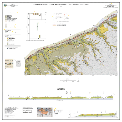
 GMS-124, Geologic map of the Biggs Junction and Rufus 7.5ʹ quadrangles, Sherman and Gilliam Counties, Oregon, by Ian P. Madin and Jason D. McClaughry; 126 p. report; 1 map plate (42 x 42 inches), scale 1:24,000; Esri format geodatabase; shapefiles; metadata; spreadsheet (2 sheets); outcrop panoramic imagery.
Report Downloads:
- Report (124 p., 54 MB PDF) | low-resolution report (9 MB)
- Map plate, with cross sections (georeferenced PDF, 19 MB)
- GIS data:
- Data spreadsheet: geochemistry and water well data (97 KB, Microsoft Excel .xlsx format)
- Full-resolution outcrop imagery (2.2 GB zip file; also see individual outcrop files below)
- Complete publication, excluding full-resolution outcrop imagery (report [high- and low-resolution report versions], map plate, geodatabase, shapefiles, metadata, spreadsheets; 83 MB zip file)
INTRODUCTION [from the report]
The geology of the Oregon portions of the Biggs Junction and Rufus 7.5ʹ quadrangles was mapped by the Oregon Department of Geology and Mineral Industries (DOGAMI) during 2018 and 2019 through USGS STATEMAP Award G18AC00136. Additional funds were provided by the State of Oregon. The objective of this mapping project is to provide an updated and spatially accurate geologic framework for northern Sherman County, as part of a multi-year study of the geology of the larger Middle Columbia Basin. Detailed geologic mapping in the Middle Columbia Basin is a high priority of the Oregon Geologic Map Advisory Committee (OGMAC).
The core products of this study are this report, an accompanying plottable geologic map and cross sections, and an Esri ArcGIS™ ArcMap™ geodatabase. The geodatabase presents new geologic mapping in a digital format consistent with the U.S. Geological Survey (USGS) National Cooperative Geologic Mapping Program 2019 draft standard format for digital publication of geologic maps, version 2 (US Geological Survey NCGMP in press). It contains spatial information about geologic polygons, contacts, and structures, and basic data about each geologic unit such as age, lithology, mineralogy, and structure. Digitization at scales of 1:8,000 or better was accomplished using a combination of 1-m lidar DEMs and 1-m 2011, 2014, and 2016 National Agriculture Imagery Program (NAIP) digital orthophoto mosaics. Nominal 1-m DEMs were produced from 1954 aerial photographs using Agisoft Photoscan TM structure from motion software. Photoscan TM was also used to produce a nominal 1 m orthomosaic from the 1954 photos, and an additional orthomosaic from 1947 aerial photos. Additional structural insight was derived from an unpublished high-resolution aeromagnetic survey image provided by Dr. Rick Blakely of the USGS (written communication, 2018). Surficial and bedrock geologic units contained in the geodatabase are depicted on Plate 1 at a scale of 1:24,000. Plate 1 also includes two interpretive cross sections derived from the digital data included in the geodatabase. Both the geodatabase and associated plottable map are supported by this report describing the geology in detail, and digital appendices with geochemical, geochronological, magnetic, structural, and water well data.
This report, digital geologic maps, and cross sections refine our understanding of geologic conditions that control the distribution, quantity, and quality of groundwater resources, the distribution of terrain susceptible to landslides, the nature of seismic hazards, and the distribution of potential aggregate sources and other mineral resources in the Oregon portions of the Biggs Junction and Rufus 7.5′ quadrangles. New detailed geologic data presented here also provides a basis for future geologic, geohydrologic, and geohazard studies in the greater Middle Columbia Basin.
GEOGRAPHIC INFORMATION SYSTEM (GIS) DATA
Geodatabase is Esri® version 10.2 format.
Metadata is embedded in the geodatabase and in the shapefiles and is also provided as separate .xml formatted files.
| BJR2019_GeMS_v10.6.gdb (geodatabase only, with embedded metadata; 4 MB, zip file) |
| Feature dataset classes |
| Name |
Description |
Metadata only
bundle (zip) |
| CartographicLines |
Vector lines that have no real-world physical existence and do not participate in map-unit topology. The feature class includes cross section lines used for cartography for the quadrangle. |
.xml |
| ContactsAndFaults |
The vector lines in this feature class contains geologic content including contacts and fault locations used to create the map unit polygon boundaries. The existence and location confidence values for the contacts and faults are provided in the feature class attribute table. |
.xml |
| DataSourcePolys |
This feature class contains polygons that delineate data sources for all parts of the geologic map. These sources may be a previously published map, new mapping, or mapping with a certain technique. For a map with one data source, for example all new mapping, this feature class contains one polygon that encompasses the map area. |
.xml |
| Geochemistry |
This feature class represents point locations where whole-rock samples have been analyzed by X-ray fluorescence (XRF) techniques in the quadrangle. Includes data collected by the authors during this study or compiled from previous studies. These data are also contained in the geochemistry spreadsheet. |
.xml |
| GeologicLines |
These vector lines represent known fold axis locations in the quadrangle. The existence and location confidence for the fold axes are provided in the feature class attribute table. |
.xml |
| MapUnitPoints |
This feature class represents points used to generate the MapUnitPolys feature class from the ContactsAndFaults feature class. |
.xml |
| MapUnitPolys |
This polygon feature class represents the geologic map units as defined by the authors. |
.xml |
| WaterWells |
This feature class represents point locations of water wells in the quadrangle. Includes data obtained by the authors from the Oregon Department of Water Resources (OWRD). These data are also contained in the WaterWells spreadsheet. |
.xml |
| Tables |
| DataSources |
Data table that contains information about data sources used to compile the geology of the area. |
.xml |
| DescriptionOfMapUnits |
Data table that captures the content of the Description of Map Units (DMU), or equivalent List of Map Units and associated pamphlet text, included in a geologic map. |
.xml |
| GeoMaterialDict |
Data table providing definitions and hierarchy for GeoMaterial names prescribed by the GeMS database schema. |
.xml |
| Glossary |
Data table that contains information about the definitions of terms used in the geodatabase. |
.xml |
| |
| SHAPEFILES (GIS shapefiles only bundle, with embedded metadata; 84 KB, zip file) |
BJR2019_Geochemistry.shp
BJR2019_RefMap.shp
BJR2019_WaterWells.shp
BJR2019_XSectionLines.shp
|
See descriptions above. |
.xml
.xml
.xml
.xml |
MAP PLATE (georeferenced PDF)
Plate 1. Geologic map of the Biggs Junction and Rufus 7.5' quadrangles, Sherman and Gilliam Counties, Oregon, scale 1:24,000
Note: The map plate PDFs are in geospatial PDF format, allowing you to turn on and off layers in the map frame and to find geographic coordinates in the PDF..
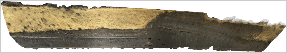
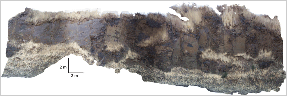
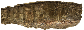
FULL RESOLUTION OUTCROP IMAGERY
In order to capture the detail and scope of large outcrops, multiple overlapping photographs were taken in the field and processed using Agisoft Metashape structure from motion software. Photographs were taken with an Apple® iPhone® SE or iPad® 2 with a native resolution of 12 megapixels, and photo locations were recorded using the camera GPS system. The photos for each outcrop were aligned in Metashape, and the aligned photos were used to generate a high-resolution point cloud and 3D model. The 3D models were oriented with a view direction that was perpendicular to the outcrop and horizontal, and that orientation was used as the plane of projection for an orthomosaic image. The resulting orthomosaics retain detail in the centimeter range.
Full figure captions are embedded in PDF properties (File > Properties...).
Note that the
images show different areas of coverage and resolution, but the final resolution limit depends how sharp each individual pre-mosaic picture was; photos taken at a distance of 10 feet will be sharper than those taken at a distance of 50 ft, regardless of the area covered.
| GMS-124 Figure Number |
|
Approx. PDF dimensions |
File Size |
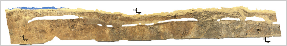
Missoula flood sand and gravel beds
|
PDF |
40 x 7 inches |
107 MB |
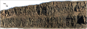
Basalt of Rosalia exposed in quarry face
|
PDF |
21 x 7 inches |
571 MB |
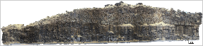
Roadcut outcrop of columnar-jointed Basalt of Roza

|
PDF |
150 x 23 inches |
122 MB |
Basal contact of Basalt of Sentinel Gap. Colonnade of Basalt of Sentinel Gap rests directly on ~1 m of hydrothermally altered sediment and flowtop of Basalt of Sand Hollow
|
PDF |
67 x 24 inches |
340 MB |
Abrupt transition of column size within the Basalt of Sand Hollow flow exposed in roadcut
|
PDF |
41 x 9 inches |
388 MB |
Complex and variable columnar, platy, and prismatic jointing in hydrothermally altered Basalt of Sand Hollow in roadcut
|
PDF |
12 x 2 inches |
303 MB |
Entablature jointing of the Basalt of Sand Hollow exposed in highwall of
quarry
|
PDF |
6 x 2 inches |
62 MB |
Upper portion of the uppermost flow of the Sentinel Gap Member exposed in cliffs

|
PDF |
183 x 52 inches |
189 MB |