[Go back] | Publications Center | DOGAMI Home
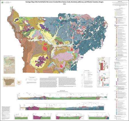
DOGAMI Bulletin 108, Geology of the North Half
of the Lower Crooked River Basin, Crook, Deschutes, Jefferson, and Wheeler
Counties, Oregon, by Jason D. McClaughry, Mark
L. Ferns, and Caroline L. Gordon; 286 p. report; 1 map plate, scale 1:63,360;
Esri format geodatabase; shapefiles; metadata; spreadsheets.
INTRODUCTION [from the report
pamphlet]
The north
half of the lower Crooked River basin encompasses an area of ~2,338 km2
(903 mi2) east of the Cascade Range in central Oregon (Figure 1‑1; plate; Hydrologic Unit Code 8 [HUC8] subbasin 17070305 referred
to herein simply as the lower Crooked River basin). Detailed
field mapping, integrated with many detailed geologic datasets, has enabled us
to reveal a long-lived and complex history of volcanism and sedimentation in
this part of central Oregon.
The lower
Crooked River basin has been a locus of magmatism for the past 47 million
years, including the formation of two large-scale Paleogene rhyolite calderas,
deposition of volcaniclastic sedimentary rocks and tuff, and eruption and
emplacement of Neogene and Quaternary basaltic lava flows. The earliest
magmatism in the lower Crooked River basin is recorded by 46.4 Ma high-MgO
alkali-olivine basalt and ~44 to 39 Ma intermediate to silicic calc-alkaline
volcanic and intrusive rocks that are part of the Eocene Clarno
Formation. Clarno volcanism, focused in the Ochoco volcanic field in the eastern half of the lower
Crooked River basin, peaked at 41.8 Ma with the eruption of the tuff of Steins
Pillar and formation of the ~16 × 11 km (10 × 7 mi) Wildcat Mountain caldera.
The Clarno Formation is overlain in the western half
of the lower Crooked River basin by a bimodal assemblage of tholeiitic mafic
lava flows and intrusions, rhyolitic tuffs, lava flows and domes, and
volcaniclastic sedimentary rocks that are part of the late Eocene to Oligocene
John Day Formation. John Day rocks in the lower Crooked River basin make up the
lower Crooked volcanic field and include the Crooked River caldera, a
large-scale ~41 × 27 km (25.5 × 17 mi) multicyclic caldera formed between 29.7
and 27.6 m.y.a. Sedimentary rocks of the early
Miocene Simtustus Formation and ~17- to 16-Ma lava
flows of the early Miocene Columbia River Basalt Group unconformably overlie
Paleogene rocks in the lower Crooked River basin. In the western part of the
basin these rocks infill the central depression of the Crooked River caldera,
recording the earliest development of the Crooked River drainage. Late Miocene
and Pliocene volcaniclastic sedimentary rocks, ash-flow tuff, and lava flows of
the Deschutes Formation, cropping out across the western part of the lower
Crooked River basin, record the onset of late High Cascades volcanism, early
development of the central Oregon segment of the High Cascades intra-arc
graben, and sedimentary and volcanic infilling of the Deschutes Basin on the
west. Mafic Deschutes Formation lava flows mapped across the western part of
the lower Crooked River basin erupted from vents in the Bowman volcanic field
between 8.8 to 3.3 m.y.a. Intracanyon
Deschutes Formation mafic lava flows, following channels incised into older
rock, record the late Neogene development of ancestral Deschutes and Crooked
River channels closely approximating present-day river courses. Pliocene and
older rocks are overlain in the western part of the lower Crooked River basin
by a broad plain of Quaternary basaltic lava flows erupted from Newberry
Volcano between 720 and 400 k.y.a. Bedrock units are
locally covered across the lower Crooked River basin by Late Pleistocene and
Holocene surficial deposits.
The geology of the lower Crooked River basin, was mapped by the Oregon Department of
Geology and Mineral Industries (DOGAMI), with the primary objective to provide
an updated and spatially accurate geologic framework for the area (Figure 1‑1; plate).
Additional key objectives of the study include: 1) determining the
geologic history of volcanic rocks in this part of central Oregon, east of the
Cascade Range; 2) characterizing the stratigraphic framework and geologic
conditions controlling the distribution of water resources; 3) mapping the
distribution of potential aggregate sources and other mineral resources; and 4)
describing the nature of geologic hazards in the region.
New detailed geologic mapping presented here also provides a basis for future
geologic, geohydrologic, and geohazard studies in the lower Crooked River basin
(Figure 1‑1; plate).
The core products of this study are this report, accompanying
geologic map and cross sections (plate), Esri ArcGIS™ geodatabase, and Microsoft Excel®
spreadsheets tabulating point data. The geodatabase presents new geologic
mapping in a digital format consistent with the U.S. Geological Survey (USGS)
National Cooperative Geologic Mapping Program Geologic Map Schema (GeMS) (U.S. Geological Survey
National Cooperative Geologic Mapping Program, 2020). It contains spatial
information, including geologic polygons, contacts, structures, as well as data
about each geologic unit such as age, lithology, and mineralogy. The
geodatabase also includes point feature classes for geochemistry,
geochronology, magnetic polarity, orientation points, volcanic vents, and well
data. Digitization at scales of 1:24,000 or larger was accomplished using a
combination of georeferenced 1:24,000-scale USGS digital raster images,
imagery, and where available, high-resolution lidar topography and imagery.
Surficial and bedrock geologic units contained in the geodatabase are depicted
on the map plate at a scale of 1:63,360 in order to
show contrasting bedrock lithology, structural relations, and surficial geology
in the lower Crooked River basin. The map plate also includes six geologic
cross sections constructed on the basis of the digital
data included in the geodatabase. Details in the geodatabase and plottable map
plate are referable to this report and accessible in
digital appendices.
Geologic mapping in the lower Crooked River basin is a high
priority of the Oregon Geologic Map Advisory Committee (OGMAC), supported in part
by grants from the STATEMAP component of the USGS National Cooperative
Geologic Mapping Program (05HQAG0037, 06HQAG0027, G20AC00202), and by the
Oregon Water Resources Department (OWRD) through Interagency Agreement DOGAMI
IAA# DASPS-2542-16/OWRD IAA 16 047 (2016). Additional funds were provided by
the State of Oregon through the Oregon Department of Geology and Mineral Industries.
GEOGRAPHIC INFORMATION SYSTEM (GIS) DATA
Geodatabase
is Esri® version 10.7 format.
Metadata is
embedded in the geodatabase and in the shapefiles and is also provided as
separate .xml formatted files.
|
Geodatabas .zip (geodatabase only, with embedded metadata, Esri® version 10.7 format; 9.2 MB zip file)
|
||
|
Feature dataset classes |
|
|
|
Name |
Description |
Metadata bundle .(zip) |
|
AlteredGeochemPoints |
This feature class represents point locations where
alteration-zone samples have been analyzed by ICP-MS and ICP-AES methods.
Includes data collected by the authors during this study or compiled from
previous studies. These data are also contained in the alteredgeochempoints
spreadsheet. |
|
|
CartographicLines |
Vector lines that have no real-world physical existence and do
not participate in map-unit topology. The feature class includes cross
section lines used for cartography. |
|
|
ContactsAndFaults |
The vector lines in this feature class contain geologic content
including contacts and fault locations used to create the map unit polygon
boundaries. The existence and location confidence values for the contacts and
faults are provided in the feature class attribute table. |
|
|
DataSourcePolys |
This feature class contains polygons that delineate data sources
for all parts of the geologic map. These sources may be a previously
published map, new mapping, or mapping with a certain technique. For a map
with one data source, for example all new mapping, this feature class
contains one polygon that encompasses the map area. |
|
|
GeochemPoints |
This feature class represents point locations where whole-rock
samples have been analyzed by X-ray fluorescence (XRF) techniques. Includes
data collected by the authors during this study or compiled from previous
studies. These data are also contained in the geochemistry spreadsheet. |
|
|
GeochronPoints |
This feature class represents point locations where isotopic
ages have been obtained for rock samples in the map area. Data collected by
the authors or compiled during the course of this
study. These data are also contained in the geochronology spreadsheet. |
|
|
GeologicLines |
These vector lines represent known fold axis locations in the
quadrangle. The existence and location confidence for the fold axes are
provided in the feature class attribute table. |
|
|
MagneticPoints |
This
feature class represents point locations where measurements of natural
remanent magnetization have been obtained for strongly magnetized lavas.
Includes data collected by the authors during the course of
this study. These data are also contained in the magnetic polarity
spreadsheet. |
|
|
MapUnitPoints |
This
feature class represents points used to generate the MapUnitPolys
feature class from the ContactsAndFaults feature
class. |
|
|
MapUnitPolys
|
This
polygon feature class represents the geologic map units as defined by the
authors. |
|
|
OrientationPoints |
This
feature class represents point locations in the map area where structural
measurements were made or were compiled from previous studies. These data are
also contained in the bedding (strike and dip) spreadsheet described in more
detail below. |
|
|
OverlayPolys |
This feature class holds the reference map
outline for each map plate. |
|
|
WellPoints |
This
feature class represents point locations of wells in the map area. Includes
data obtained by the authors from the Oregon Department of Water Resources
(OWRD). These data are also contained in the Wells Points spreadsheet. |
|
|
VentPoints |
This
feature class represents point locations of volcanic vents in the map area.
These data are also contained in the Vent Points spreadsheet. |
|
|
Tables |
|
|
|
DataSources |
Data table that contains information about data sources used to
compile the geology of the area. |
|
|
DescriptionOfMapUnits |
Data table that captures the content of the Description of Map
Units (DMU), or equivalent List of Map Units and associated pamphlet text,
included in a geologic map. |
.xml
|
|
GeoMaterialDict |
Data table providing definitions and hierarchy for GeoMaterial names prescribed by the GeMS
database schema. |
|
|
Glossary |
Data table that contains information about the definitions of
terms used in the geodatabase. |
|
|
Shapefiles (GIS shapefiles only bundle, with metadata; 652 KB,
zip file) |
|
|
|
LCB2021_AlteredGeochemPoints.shp |
See descriptions above |
.xml
|
|
LCB2021_AlteredZones.shp |
.xml
|
|
|
LCB2021_GeochemPoints.shp |
.xml
|
|
|
LCB2021_GeochronPoints.shp |
||
|
LCB2021_MagneticPoints.shp |
.xml
|
|
|
LCB2021_OrientationPoints.shp |
.xml
|
|
|
LCB2021_RefMap.shp |
.xml
|
|
|
LCB2021_VentPoints.shp |
.xml
|
|
|
LCB2021_WellPoints.shp |
.xml
|
|
|
LCB2021_XSectionLines.shp |
.xml
|
|
MAP PLATES (georeferenced
PDFs)
Note: The
map plate PDF is in geospatial PDF format, allowing you to turn on and off
layers in the map frame and to find geographic coordinates in the PDF.
Plate. Geologic Map of the North Half of the Lower Crooked River Basin, Crook, Deschutes, Jefferson, and Wheeler Counties, Oregon, scale 1:63,360, 64" x 60”