DOGAMI Interpretive Map Series
[Go back] | Publications Center | DOGAMI Home
Publication Preview
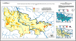 IMS-14, Relative earthquake hazard map of the Eugene-Springfield metropolitan area, Lane County, Oregon, by Gerald L. Black, Zhenming Wang, Thomas J. Wiley, Yumei Wang, and David K. Keefer, 2000, 16 p., Relative Earthquake Hazard Map, 1:48,000; Amplification Map, Liquefaction Map, and Slope Instability Map, 1:150,000. Zip file contains explanatory text, metadata, and GIS files.
Map plate (PDF, 40 x 22 inches, scale 1:48,000)
readme.txt (accompanies CD-ROM version of publication)
metadata text ( html | text )
explanatory text (pdf)
ArcView GIS files (zipped)
MapInfo GIS files (zipped)