[Go back] | Publications Center | DOGAMI Home
Oregon Geothermal Power Plant Sites, Release 1 (ORGPP-1), compiled by Clark A. Niewendorp.
See below for ORGPP-1 publication contents.
ORGPP-1 data can be downloaded from the page: Geothermal Information Layer for Oregon data download page
The Oregon Department of Geology and Mineral Industries (DOGAMI) received American Recovery and Reinvestment Act of 2008 funding to compile all DOGAMI legacy geothermal information and make it available to the public and industry. The Oregon Geothermal Power Production (ORGPP-1) publication is the Oregon Department of Geology and Mineral Industries (DOGAMI) geospatial database of Oregon geothermal power plant information.
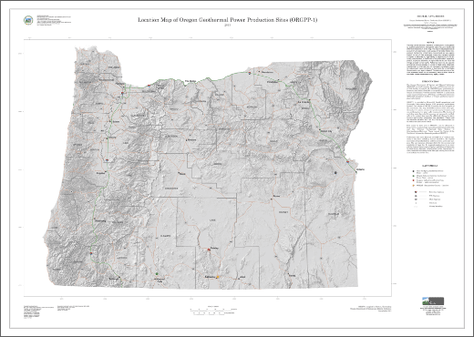
ORGPP-1 is provided in Microsoft® Excel® spreadsheet and Geographic Information System (GIS) geospatial geodatabase formats. This release of ORGPP-1 contains one Esri shapefile of the same name. This map shows the locations of two active geothermal power plants, one inactive geothermal powerplant, and one geothermal power plant under construction. The location of each data point shown in this map was not necessarily verified; refer to the original data source for additional information about location and location uncertainty (see metadata). Please read the shapefile metadata.
These data are provided “as is” without warranty
of any kind, including, but not limited to, the implied
warranties of merchantability and fitness for a particular purpose.
The user assumes all responsibility for the accuracy and
suitability of these data for a specific application. In no event
will the Oregon Department of Geology and Mineral Industries
be liable for any damages, including lost profits, lost savings, or
other incidental or consequential damages arising from the use
of or inability to use the data.
Contents
This publication contains:
1. "map" folder: Contains portable document format (PDF) 1:500,000-scale (73- by 52-inch plate) mapview of the data in PDF format in both onscreen and high-resolution versions.
2. "shp" folder: Contains files in shape file format - native file format of ArcMAP GIS software by Esri, Redlands, California. There is one shapefile: ORGPP-1.
3. "spreadsheet" folder: Contains tables in Microsoft Excel format. Please read the metadata for description of Field Names.
Disclaimer
This map cannot serve as a substitute for site-specific investigations
by qualified practitioners. Site-specific data may give results that
differ from those shown on the map. This report was prepared as an
account of work sponsored by an agency of the United States Government.
Neither the United States Government nor any agency
thereof, nor any of their employees, makes any warranty, express
or implied, or assumes any legal liability or responsibility for the accuracy,
completeness, or usefulness of any information, apparatus,
product, or process disclosed, or represents that its use would not
infringe privately owned rights. Reference herein to any specific
commercial product, process, or service by trade name, trademark,
manufacturer, or otherwise does not necessarily constitute or imply
its endorsement, recommendation, or favoring by the United States
Government or any agency thereof. The views and opinions of authors
expressed herein do not necessarily state or reflect those of
the United States Government or any agency thereof.
Funding
This material is based upon work supported by the Department of Energy's Geothermal Technologies Office
and between the Arizona Geological Survey (Sponsor) and the Oregon Department of Geology and Mineral
Industries (Subrecipient) under Award Number(s): Prime Award No. DE_EE0002850 and
Sub Award No. OR-EE0002850.